Location: 26781 WA-31, Metaline Falls, WA 99153
The Metaline Falls Border Station has been associated with the broad pattern of history in the State of Washington and has been a recognized element in the economic development of the region. As a border station it is associated also with the emergence of land borders versus seaports as the primary gateways into the U.S., a development attributed to popularity of auto travel and road construction.
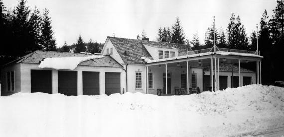
The materials, method of construction and design of the Metaline Falls Border Station are representative of the “northern type” border station. This type was designed and constructed at remote locations along the US/Canadian border by the department of the Treasury in the 1930s. At Metaline Falls, this station type included a single inspection building which was shared by two distinct federal agencies: the US Customs Service and the U.S. Immigration Service (later the Immigration and Naturalization Service, or INS).
Because of their typically remote locations, the “northern type” plan also included two, nearly identical, on-site residences for station personnel. The station sites and individual buildings were typically characterized by bi-axial symmetry, expressive of the shared use of a Border Station, and by Georgian style architectural designs which were selected to represent the democratic ideals of the U.S. government.
There were 48 land-based U.S. border stations constructed in the 1930s. Those of the “Northern Type” are along the Canadian border, particularly in Vermont, North Dakota, Montana, Idaho and Washington. These stations emphasized customs and immigration functions equally. In contrast, stations constructed after WWII, particularly those along the U.S./Mexico border, emphasize immigration functions. Architecturally, the original “northern type” buildings also express the colder climates of their northern location, with steep roof gables and roof overhangs which shed rain and snow. Regional wood materials were used typically for framing, cladding, and finishes.
Historic Context
The history of the Pend Oreville River region in NE Washington, prior to the white settlement, was that of the Kalispel and Pend Oreille Indians who settled the region 8,000 to 10,000 years ago. Early whites included fur traders of the Hudson’s Bay Company in the early 1800s, and missionaries who settled to the east in the Fort Colville are in the 1830s and 1840s.
Territorial history in the Metaline Falls area was dominated by the discovery of gold and development of placer mines. These discoveries began in the Idaho panhandle in 1860. Later discoveries of silver and lead ore led to hard-rock mining in the Selkirk Mountains surrounding the upper Pend Oreville River area of NE Washington, the Coeur d’ Alene Mountains in Idaho, and the nearby Monashee Mountains in British Columbia. The lode mining industry of the “Inland Empire,” a region stretching from the middle of Washington State, east of Columbia River and into Idaho, began in the mid-1880s. Lode mining encompassed claims in the Pend Oreille district of northern Idaho, the Metaline district of NE Washington, and the Nelson district of Canada. The region’s mining industry contributed to cross-border commerce between the two countries.
The US Customs Service, which constructed and continues to use the Metaline Falls Border Station, has been associated with Metaline Falls for 73 years of the town’s 85 year history. Metaline Falls, located on the Pend Oreille River approximately 10 miles south of the station, was homesteaded by pioneer Enoch Carr. Discovery of lead resulted in a population boom in the late 1870s and led to increased transportation demands, which were met by the arrival of the Milwaukee Railroad ca. 1910. Promotion of Metaline Falls by the Mammoth and Morning mines also brought settlers to the town. In 1909-1910, Lewis P. Larsen purchased and surveyed Enoch Carr’s property, and laid out the town.
Larsen and business associate, Jens Jensen, constructed a sawmill on Sullivan Creek, and established the town’s Lehigh Cement Company plant. The plant, established in the 1920s, too advantage of nearby cement materials, fire clay, and lime materials found in the region. Its development anticipated further mining and infrastructure and road contracture in northeast Washington. (The Lehigh plant closed in the early 1990s, forcing Metaline Falls to depend on increased tourism for its economic base).
A road connecting Metaline Falls to the border was constructed in 1923 and by 1929 it was completed, linking Metaline Falls with Nelson, British Columbia. At time time a US Customs Station was established in the Washington Hotel in Metaline Falls, and State Highway No. 31 was unpaved and seldom traveled. Typical traffic included miners working in nearby mines, and loggers from forested login sites and sawmills. Propr to the road’s construction, the area linking Metaline Falls north to Salmo and Nelson, Canada, was traversed by many trails.
When prohibition was enacted in the US (1920-1933), the trails were used for smuggling liquor, and became known as “whiskey trails.” Prohibition was the impetus for congressional funding for many of the northern border stations in the 1920s and early 1930s in the effort to stop such smuggling.
In 1939, the Trans-Canada Highway was constructed approximately 100 miles north of the US border. This highway was connected to smaller state and local roads in the US and represented the increased use of private automobiles throughout North America. It affected vehicular traffic across northern Washington. Auto travel also affected immigration patterns. Previous immigrants had entered the US primarily by sea, arriving at port cities. The new road system, by contrast, allowed land access at numerous, discrete points, thus resulting in increased immigration processing at the border crossings.
Traffic through the Metaline Falls Border Station has increased steadily since its opening. In 1929, 3,368 vehicles and 9,265 people (both citizens and aliens) entered the US at this point. In 1987 over 24,470 vehicles and 71,000 people entered. By fiscal year 1996, the number of people crossing the border annually had increased to over 94,330.
The Metaline Falls Border Station’s functions have changed along with the region’s economy. Pend Oreille County’s development was first by mining, them by timber extraction, cattle ranging, and tourism. The Colville National Forrest, which surrounds the Metaline Falls area, was established in 1906, and comprises over 1,030,00 acres. Estimated annual visitation - - by hikers, hunters, and fishermen - - numbers over 1.4 million people. Despite increased tourism, the northeast region of Washington state remains sparsely populated. Pend Oreille County has an estimated population of 10,700 in 1995, and Metaline Falls, its second largest town, had 210 residents. In this remote area, the US Border Station has remained a significant element in the regional economy.
The Architect and the Building’s Construction
The design of the Metaline Falls Border Station is credited to the Department of the Treasury under the direction of James Wetmore and the Supervising Architect, Louis A. Simon. Simon (1867-1958) was educated at MIT and worker in the Treasury Department from 1896 to 1941. He advocated the use of simplified classicism and American Colonial Revival styles as appropriate expressions for government buildings. Simon oversaw the design of a number of standardized federal building plans in Washington state, including the US Border Stations at Sumas, Lyden, Laurier, Oroville and Ferry, and Portville and Eastport in Idaho, all of which were constructed in the early 1930s.
During the Great Depression of 1930s, a number of federally-funded building programs were created to sponsor public work. These included the Works Progress Administration (WPA) and the Civilian Conservation Corps (CCC). The Metaline Falls facility, in contrast, was competitively bid and built by a private contractor, L. Jones of Seattle, in accordance with the federal legislation that provided its funding. Construction work began in late 1931 and was completed in 1933.
Facts
- Architects: Simon, Louis A.
- Construction Dates: 1931-1932
- GSA Building Number: WA0611MB
- Landmark Status: Listed in the National Register of Historic Places

 U.S. General Services Administration
